TH: Maroon-Snowmass; Maroon Lake
Total Mileage: 27.10 miles
Total Vertical Gain: 8,441 feet
Low Point: 9,566 ft
High Point: 12,543 ft
Time: 8:08:20
I read about this route several years back. It is traditionally done as a 3 day backpacking trip. We planned to do the trip over the July 4th weekend in 2009. Unfortunately many of the passes were still stuck in snow and we had to change our plans. We opted for hiking to the base of Capitol Peak. I've been dying to get there ever since. I started running ultras 2 years ago and this year I signed up for the Leadville 100. This would be a perfect training run. I set off at 6:30am with my Nathan Hydration Vest and 2 handhelds. The temps were pretty warm and there were spotty clouds. Beautiful day all around but I didn't account for the heat properly with my hydration.
There aren't too many routes that start with the money shot but this one does. The trailhead has one of the most photographed views in Colorado and for good reason. The photo from the morning of my run shows a perfect reflection of the Maroon Bells on Maroon Lake. I couldn't wait to see what else was in store.
 |
climb up to Buckskin Pass. Sleeping Sexton and
N Maroon Peak. |
I took the route going counter clockwise for no reason other than that is the way I read most trip reports. The trail starts at Maroon Lake and eases you into the loop by gaining about 600 feet in a mile and half to Crater Lake. From that point the trail jogs WNW as it works its way up Minnehaha Gulch to Buckskin Pass.
 |
| Capitol Peak14,130 ft |
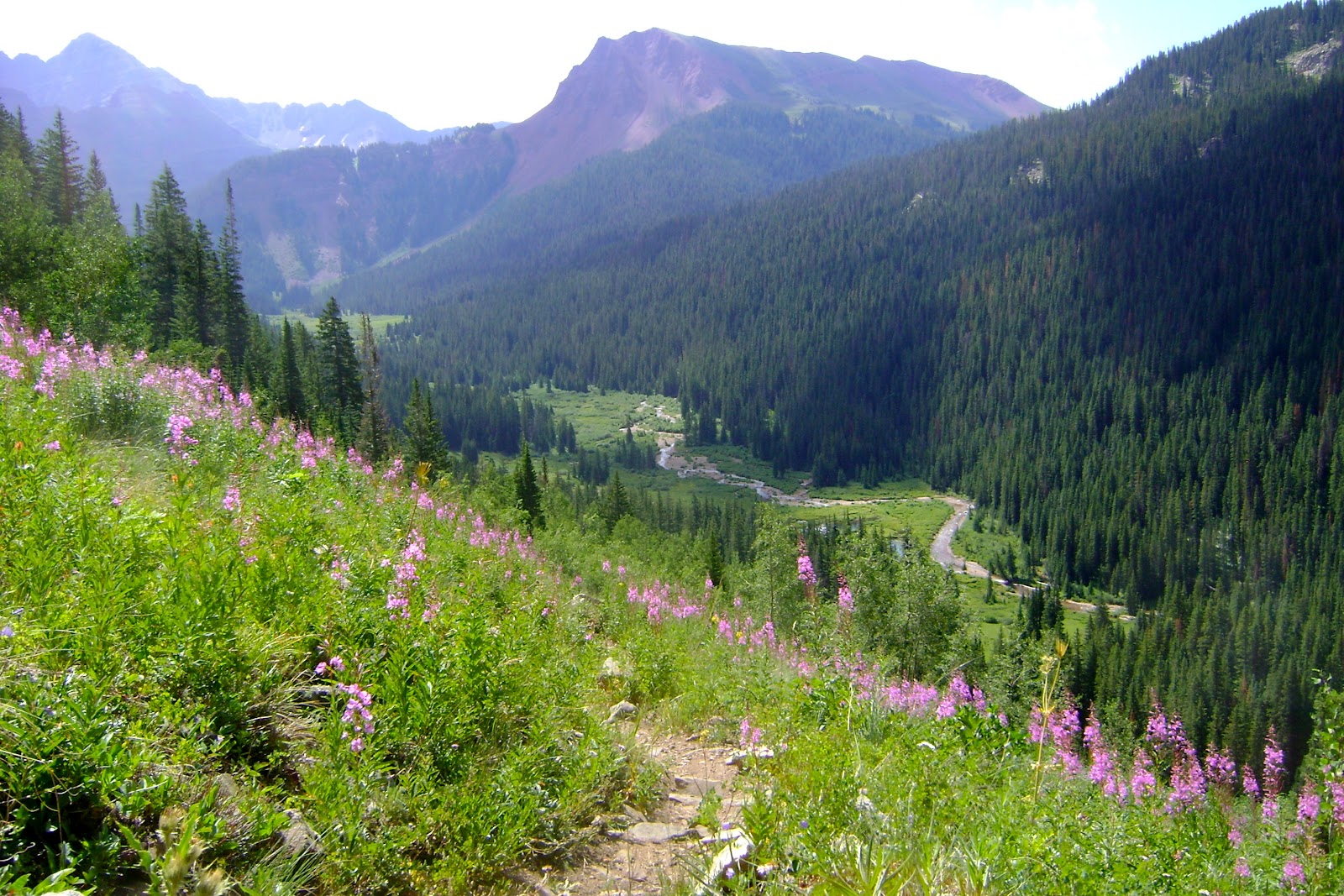
The climb up is beautiful. There were some climbers working their way up Sleeping Sexton. Before reaching the top of the pass there is a trail junction. The trail to the right heads up to Willow Pass and down to Willow Lake. I headed left up to Buckskin Pass. As you top off on top of the pass you are rewarded for the 3,000 feet gained in the first 5 miles. Capitol Peak looms straight ahead. This 14er is famous for its knife edge near the summit.
The trail is pretty straight forward as it drops off the backside of the pass. It works its way down into some very plush pine forest. I came across a group of backpackers as I neared Snowmass Creek. This part of the Snowmass Creek is meandering and calm. As you approach the creek their is a trail that jogs off to the left. Do not take that trail. Continue along the right side of the river. You will come across a beaver dam pretty quick. Shortly after that you will cross the creek over a log bridge. This year was
 |
continue on right side of stream
was bad for snowpack so I didn't encounter too many problems with stream crossing. I imagine on a good snow year there would be some water and mud you will need to work through after crossing the bridge. |
 |
Snowmass Lake from trail. View
towards Heckert Pass. |
 |
Snowmass Mountain on way up to
Trail Rider Pass. |
The trail continues on towards Snowmass Lake. As you near the lake there is a trail to the right. This trial leads to some campsites as it winds down close to the lake. I did not go this way. I imagine you can snag a great pick of Snowmass Lake with Snowmass Peak in the background from that trail. It may add 1/4 - 1/2 mile to your trip. It will hook back up with the Geneva Lake Trail that brings you up to Trail Rider Pass.
 |
| Up to Trail Rider Pass. |

There were a few backpackers taking off from Snowmass Lake. I spoke with a couple of them as I was climbing up Trial Rider Pass. They didn't have much luck fishing but they said that another group had a done pretty well. The climb up Trail Rider is pretty tough but once you get to the top the descent down to the North Fork River is nice.

Shortly after dropping down off Trail Rider Pass you will pass a small pond on your right. About a 1/4 mile after that there is another trial junction. Go left to continue with the 4 pass loop. Going right will bring you to Geneva Lake. You can add a couple of miles by taking this route and looping it back to the North Fork Fravert Basin Trail. I had considered this in my planning but was feeling the affects of the altitude, heat and poor fueling. I went left at the junction via the North Fork Cutoff Trail.
From the top of Trail Rider to the waterfall that marks the climb into Fervent Basin there is some great trail that is prime for running. The temps rose noticeably as I dropped down to the North Fork River. I was starting to run low on water. I was down to about 20 ounces. I am terrified of giardia and will only take water from high streams high above trails. On a normal year these streams are bountiful but this year they were mostly dried up. The North Fork River would have been great if I had a steripen or iodine. I powered on figuring something would pop up as I climbed Fravert Basin.
 |
| Fravert Basin. Belleview Mountain straight ahead. |
I came across 3 groups of backpackers during this section of trail. One group I met at the river crossing. They were on the other side of the river looking for a place to cross. I came to the river and just ran right through it. It was thigh high and felt great. I didn't stick around to find out how they got across.
Within about 1/2 a mile from the river crossing is a spectacular waterfall. The climb is steep as you hit the switch backs to get to the top of the falls. From there the climb is steady as the trail stretches up Fravert Basin to Frigid Air Pass. This is a spectacular basin with the most amazing collection of wildflowers I have ever seen. Frigid Air Pass rises on the right. Belleview Mountain looms ahead and the backside of Maroon Peak rises to the left. Unfortunately I had misjudged my water opportunities and I was down to nothing as I climbed Frigid Air Pass.
 |
| Backside of Maroon Peak with wildflowers. |
 |
| View back down Fravert Basin from Frigid Air Pass. |
There is a lake in the picture to the left. I could see a break in the terrain where I knew a stream would be flowing down. I was counting on that for water. Unfortunately it was dry. I was down to nearly nothing as I reached the top of Frigid Air Pass. I took a few minutes to sit and take in the amazing views and tried to put down a bar. I could only get half of it down. I had waited too long and know I was going to pay the price.
There is a TH off the backside of Frigid Air Pass as the trail bends towards West Maroon pass. As a result the trail becomes a little more "crowded". I dropped down off of Frigid Air Pass and was grateful that the trail did not drop as low as the previous passes. The trail drops down only 500 feet and heads SE. Thankfully I came across a stream that met my criteria as safe about a mile from the pass. I filled up my hydration pouch and drank about 30 ounces as I sat at the stream. Unfortunately I was already pretty depleted and the rest of the run was mostly walking. This was tough because I was so close to the final descent.
 |
| Final climb up West Maroon Pass. |
Only 700 feet of climb for the last pass. I made my way up the pass. The counter clockwise route is nice because the final climb is not very long. Fravert Basin is runnable heading up to Frigid Air Pass if you are feeling strong. It would be a spectacular and very fun run if you did the route clockwise. Going clockwise would leave you with a very long climb over Buckskin. Maybe I'll try the route in reverse some day.
 |
| Maroon Peak approaching Crater Lake. |
 |
| Snow in crevasse between peaks. |
I topped of on West Maroon Pass. I hardly even stopped as there were several people up there who had climbed from the nearby TH. I wasn't in the mood in the condition I was in. I dropped down for the last 7 miles down to the TH. The last 5 mile of trail is a bit rockier than the rest of the run. The brush grows tall and tight in some sections. I wondered how many hikers have run into a bear in similar sections. There are several campsites as you near the base of the Bells. The Bells are a remarkable set of mountains. I enjoyed watching them change as I gained different vantage points. Although the traditional view is hard to beat the beauty of these peaks is worth seeing from all sides.
 |
| Me knocking one off my life list! |
I look forward to doing this again either as a run or a backpacking trip. There are several side trips and summits that are accesible on this trail that would make an extended trip worthwhile. If I do run it again I hope to knock off about 45 minutes.